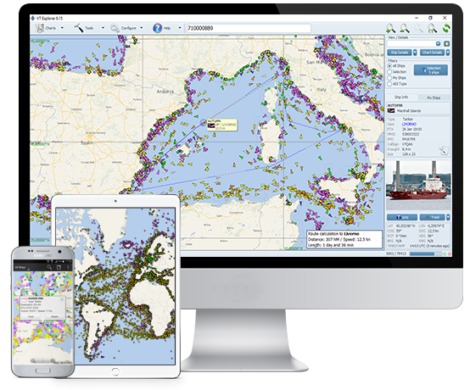
AIS vessel tracking by VT Explorer
VT Explorer is a vessel tracking system based on collecting, processing and displaying real time vessel tracking data received from vessels' AIS transponders. VT Explorer is designed and developed by Astra Paging Ltd with main purpose to provide real time vessel tracking to all companies and organizations involved in maritime business.
Our vessel tracking services are used by many shipowners, managers, operators, charterers and insurance agents. Customized versions of VT Explorer have been introduced into the daily activities of many state agencies, such as the Bulgarian Maritime Administration, Bulgarian Navy, Border Police, etc. The system has been successfully tested during several international naval exercises to ensure safety during the naval gun exercises and coordination of the joint SAR activities between Bulgarian Navy and Maritime Administration.
Vessel tracking network
The real time vessel tracking is secured by receiving and processing of data transmitted by all AIS equipped vessels in the area of coverage. The data is collected via a network of AIS receivers. It is processed on the central AIS server and stored in VT Explorer vessel tracking database. Real time data access is only granted to the system subscribers.
VT Explorer system comprises several chain-linked subsystems:
- Onboard AIS Transponders - the primary source of VT Explorer data are the AIS transponders installed on more than 70,000 vessels. No changes to the existing onboard equipment or additional setup procedures are required.
- AIS Receiving Stations - hundreds AIS receiving stations located in different regions of the Earth receive AIS data transmissions and send the raw information via Internet to our Data Processing Centre.
- AIS Data Processing - our AIS server processes and stores the data received from the receiving stations.
- Vessel Traffic Database - VT Explorer database archives all vessel positions received by the system. Each month our archive grows with more than 100 million new records.
- Vessel Traffic Viewer - visualization of the ship positions is secured through the "VT Explorer" software application. This application retrieves the data via Internet on regular time intervals and displays the current ships positions onto electronic chart.
Vessel traffic viewer
VT Explorer vessel traffic viewer is a software application that provides a graphic display of AIS targets onto electronic chart. The powerfull VT Explorer functionality allows the user to study AIS traffic patterns. The vessel positions are shown with different symbols depending on their type, course and speed. For example yellow colour is used for general cargo vessels, orange - for tanker vessels and green - for passenger vessels. It is also possible to filter vessels by different selection criteria. Vessel positions are plotted against high level coastal maps, but, as the user zooms in to take a closer look additional details at the port are displayed.
All data about individual vessels are accessible by a single mouse click and presented in a simple way. Compared to similar web-based products, VT Explorer does not require fast Internet connection and provides fast operation even on low-end computer hardware.
The interface provides a ship search by name, IMO or MMSI number , visualization of the ship track for last 72 hours, distance calculation etc. A separate web based "Traffic Analysis" module provides tools for definition of tri gger events and submission of e-mail and SMS messages when particular ship arrives at the selected port.


24/7 live AIS coverage