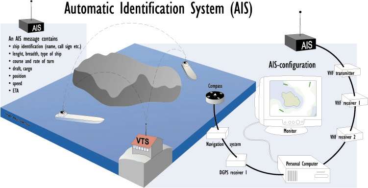
AIS is a maritime navigation safety communications system adopted by the International Maritime Organization (IMO) to provide vessel information, primarily for the purposes of maritime safety. AIS data provides a source of information which can be used to spatially represent vessel movements within the receiving range of transmissions.
The technology works with transponders which automatically broadcast information at regular intervals by Very High Frequency (VHF) transmitter. The AIS system is capable of handling well over 4,500 reports per minute and updates as often as every two seconds. To manage the automatic transmission and receipt of messages, AIS uses ‘Self-Organised Time Division Multiple Access’ (SOTDMA) technology to meet this high broadcast rate and ensure reliable ship-to-ship communications. AIS technology allows the display of information previously only available to modern Vessel Traffic Service (VTS) centres and provides much clearer information allowing mariners to more accurately identify and contact any vessel within VHF range.
AIS signals are broadly classified as ‘Class A’ and ‘Class B’, where AIS-A is carried by international voyaging ships with gross tonnage (GT) of 300 or more tonnes, and all passenger ships regardless of size. AIS-B is carried by smaller vessels and is aimed at smaller commercial vessels, the fishing sector and recreational vessel users. There are currently 27 different AIS message types which are used in combination to provide AIS-A and AIS-B services.
The most commonly used data from AIS messages is the position of a vessel at any given time which is combined with voyage information about the vessel’s trip.
Position reports are broadcast very frequently (between 2 to 10 seconds, depending on the vessels speed, or every 3 minutes if at anchor) whilst static and voyage related reports are sent every 6 minutes. Other types of messages include search and rescue transmissions, Aid to Navigation (buoys, lights and beacons) and Base Stations which provide meteorological, hydrological and navigation safety information.
The range of reception can be variable and is dependent on factors including signal propagation conditions, sea state, the height of the transmitting and receiving antenna and the strength of the vessel transmitter. Reception could be as little as 20 nautical miles, or as much as 350 nautical miles for powerful transmissions during appropriate atmospheric conditions. In the context of the factors that act to control AIS reception range it is considered likely that on average a 40 nautical mile reception radius will be achieved by the AIS receiver network. The same coverage assumptions do not apply to AIS-B which has a smaller power output with ranges of up to 10 nautical miles.